

Google Maps –
A cluster of earthquakes was recorded northeast of Hawthorne last week, the biggest being a 4.5 Thursday at 4:40 p.m.
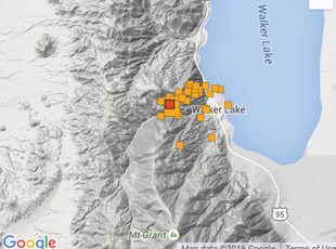
Residents in Mineral County were jolted again, not once, but twice last Thursday after a pair of strong earthquakes hit the area just minutes apart in the late afternoon hours.
The Mineral County Sheriff’s office said there were no reports of damage from the 4.3 and 4.5 temblors that struck about 12 miles northeast of Hawthorne near Walker Lake, although there were some within the community that had items fall from shelves and out of cabinets. There were more than 70 small quakes that followed the two big ones, none of which registered more than a 1.3 on the scale.
“There were a couple of significant events that we recorded, but the activity has since slowed a bit,” said Annie Kell, Outreach Seismologist at the University of Nevada, Reno.
The shaking is nothing new for Mineral County. The area had a large cluster in 2011 that resulted in thousands of earthquakes and a handful that were over 4.0. Kell explained that they were all related to the Wassuk fault line that stretches from around 30 miles north to south from Schurz just past Hawthorne.
“It’s a region of active tectonic’s,” she said. “The length of the Wassuk fault could easily produce an earthquake between 6.0 and 7.0.”
While it’s impossible for seismologists to predict an earthquake, the UNR Seismology department has monitoring stations on TV Hill and at the Hawthorne Army Depot to keep track of every event in the area.
For now, Kell says the best thing people can do is be aware of the possibility and be prepared by having a plan in place and making an earthquake kit.
For preparedness tips and to keep track of all the seismic activity in Nevada, visit www.seismo.unr.edu.

